Physical
| Dimensions |
287 x 166 x 90 mm (11.30 x 6.55 x 3.50″)with bracket 311 x 180 x 95 (11.30 x 7.07 x 3.72) |
| Weight |
1.41kg/3.11lb |
Environmental
| Operating temperature range |
-15°C to +55°C (5° F to 131° F) |
| Environment Shock Vibration |
100,000 cycles of 20G |
| Storage temperature range |
-20°C to +60°C (4°F to 140°F) |
| Water resitance |
IPX6 and 7 |
Power
| Supply voltage |
10 – 31.2 V DC |
| Fuse rating |
5A |
| Power consumption (Max) |
21W |
Display
| Display backlight color |
White |
| Display resolution |
600 x 1280 |
| Display screen brightness |
1200 nits |
| Display size and type |
High Visibility SolarMax HD® IPS 7″ optically bonded TFT |
| Display viewing angles |
80° top/bottom, 80° left/right |
Connectivity
| Ethernet |
1 x 5 pin yellow connector x 1 Mbit |
| Bluetooth |
Internal |
| NMEA2000 connectivity |
1 x NMEA 2000 Micro-C port, 1 LEN |
Receive only
- 59392 ISO Acknowledgement
- 59904 ISO Request
- 60160 ISO Transport Protocol, Data Transfer
- 60416 ISO Transport Protocol, Connection M.
- 65240 ISO Commanded Address
- 60928 ISO Address Claim
- 126208 ISO Command Group Function
- 126992 System Time
- 126996 Product Info
- 126998 Configuration Information
- 127233 Man Overboard Notification (MOB)
- 127237 Heading/Track Control
- 127245 Rudder
- 127250 Vessel Heading
- 127251 Rate of Turn
- 127252 Heave
- 127257 Attitude
- 127258 Magnetic Variation
- 127488 Engine Parameters, Rapid Update
- 127489 Engine Parameters, Dynamic
- 127493 Transmission Parameters, Dynamic
- 127500 Load Controller Connection State / Control
- 127501 Binary Status Report
- 127503 AC input status
- 127504 AC Output Status
- 127505 Fluid Level
- 127506 DC Detailed Status
- 127507 Charger Status
- 127508 Battery Status
- 127509 Inverter Status
- 128259 Speed, Water referenced
- 128267 Water Depth
- 128275 Distance Log
- 129025 Position, Rapid Update
- 129026 COG & SOG, Rapid Update
- 129029 GNSS Position Data
- 129033 Time & Date
- 129038 AIS Class A Position Report
- 129039 AIS Class B Position Report
- 129040 AIS Class B Extended Position Report
- 129041 AIS aids to Navigation
- 129283 Cross Track Error
- 129284 Navigation Data
- 129539 GNSS DOPs
- 129540 AIS Class B Extended Position Report
- 129545 GNSS RAIM Output
- 129549 DGNSS Corrections
- 129551 GNSS Differential Correction Receiver Signal
- 129793 AIS UTC and Date Report
- 129794 AIS aids to Navigation
- 129798 AIS SAR Aircraft Position Report
- 129801 Cross Track Error
- 129802 AIS Safety Related Broadcast Message
- 129283 Cross Track Error
- 129284 Navigation Data
- 129539 GNSS DOPs
- 129540 GNSS Sats in View
- 129794 AIS Class A Static and Voyage Related Data
- 129801 AIS Addressed Safety Related Message
- 129802 AIS Safety Related Broadcast Message
- 129808 DSC Call Information
- 129809 AIS Class B “CS” Static Data Report, Part A
- 129810 AIS Class B “CS” Static Data Report, Part B
- 130060 Label
- 130074 Route and WP Service – WP List – WP Name & Position
- 130306 Wind Data
- 130310 Environmental Parameters
- 130311 Environmental Parameters
- 130312 Temperature
- 130313 Humidity
- 130314 Actual Pressure
- 130316 Temperature, Extended Range
- 130569 Entertainment – Current File and Status
- 130570 Entertainment – Library Data File
- 130571 Entertainment – Library Data Group
- 130572 Entertainment – Library Data Search
- 130573 Entertainment – Supported Source Data
- 130574 Entertainment – Supported Zone Data
- 130576 Small Craft Status
- 130577 Direction Data
- 130578 Vessel Speed Components
- 130579 Entertainment – System Configuration Status
- 130580 Entertainment – System Configuration Status
- 130581 Entertainment – Zone Configuration Status
- 130582 Entertainment – Zone Volume Status
- 130583 Entertainment – Available Audio EQ Presets
- 130584 Entertainment – Bluetooth Devices
- 130585 Entertainment – Bluetooth Source Status
NMEA 2000 PGN’s Transmit
- 60160 ISO Transport Protocol, Data Transfer
- 60416 ISO Transport Protocol, Connection M.
- 126208 ISO Command Group Function
- 126992 System Time
- 126993 Heartbeat
- 126996 Product Info
- 127237 Heading/Track Control
- 127250 Vessel Heading
- 127258 Magnetic Variation
- 127502 Switch Bank Control
- 128259 Speed, Water referenced
- 128267 Water Depth
- 128275 Distance Log
- 129025 Position, Rapid Update
- 129026 COG & SOG, Rapid Update
- 129029 GNSS Position Data
- 129283 Cross Track Error
- 129285 Navigation – Route/WP Information
- 129284 Navigation Data
- 129285 Route/Waypoint Data
- 129539 GNSS DOPs
- 129540 GNSS Sats in View
- 130074 Route and WP Service – WP List – WP Name & Position
- 130306 Wind Data
- 130310 Environmental Parameters
- 130311 Environmental Parameters
- 130312 Temperature
- 130577 Direction Data
- 130578 Vessel Speed Components
| NMEA 0183 connectivity |
1 x Transmit, 1 x Receive NMEA 0183, Baud Rates 4800, 9600, 19200, 38400. TX and RX use same baud rate. Optional data cable required (P/N 000-00129-001) |
| NMEA 0183 sentences |
Input: GGA, GLL, GSA, GSV, VTG, ZDA, RMC, DBT, DPT, MTW, VLW, VHW, HDG, HDT, HDM, MWV, MWD, DSC, DSE, VDM. (Note AIS sentences are not bridged to or from NMEA 2000) Output GGA, GLL, GSA, GSV, VTG, ZDA, RMC, DBT, DPT, MTW, VLW, VHW, HDG, MWV, MWD, TLL, TTM” |
| Video connectivity |
2 x composite (RCA connectors)video inputs. Optional video/ data cable required (P/N 000-00129-001). |
| WiFi connectivity |
Internal |
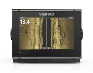
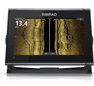
Sonar
| Sonar frequencies |
40-250kHz 455-800kHz |
| Sonar max depth |
3000’+ (tested with B175L) |
| Sonar output power |
1kW RMS |
| Compliance |
CE, C-Tick,HDMI(12&16″), EN 60950-1:2006, EN 60945:2002 |
EN 300 440-2, V1.4.2
GPS
| GPS |
Internal |
| GPS update rate |
10 Hz |
| GPS channels |
34 Channels |
| GPS correction |
WASS, EGNOS, MSAS, GLONASS |
| GPS position accuracy |
Horizontal Accuracy 3 m (9.8 ft) |
| GPS time to first fix |
Cold start 50 sec, Satellite Reacquisition 5 sec |
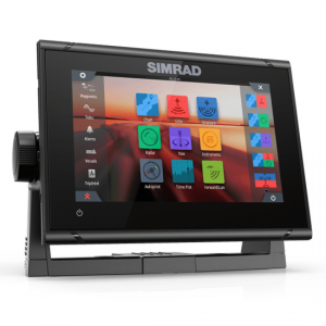
Features
| Interface |
Full touch screen (multi-touch ) and full keypad control, OP50 remote controllers |
| Charts Incuded |
Insight |
| Radar |
Broadband Radar, Halo Pulse Compression Radar, HD Pulse Radar |
| Sonar |
Two 9 pin Xsonic Sonar ports. Sonar port 1: Single channel CHIRP, 50/200 khz, HDI. Sonar port 2: Single channel CHIRP, 50/200 khz, TotalScan, LSS HD, ForwardScan.Compatible with: SonarHub, BSM-3, BSM-2, network echo sounders” |
| Weather |
SiriusXM via WM-3 (USA only), GRIB |
| AIS |
Receive AIS data over NMEA 2000 or *NMEA 0183 (has to be wired to all NSS processors) |
| Auto pilot integration |
Full auto pilot control and commissioning |
| Autopilot steering modes |
Auto, Nav., No Drift, Follow up, Non-follow up, Turn patterns, Standby, *Wind, *Wind NAV. (*Boat type set to Sail) |
| Autopilot manouevres turn patterns |
U-turn, Spiral-turn, C-turn, Zig-zag, Square-turn, Lazy S-turn, Depth contour tracking |
| Supported Charts |
Insight, Navionics (Gold, NAV+ Platinum+) , C-MAP (MAX N, MAX N+) NV Digital (Raster US Charts) |
| Digital switching |
BEP C-Zone, Naviop |
| External storage |
2 MicroSD slots, max. 32GB each. Larger if formatted to NTFS |
| Internal storage |
16 GB |
| Multi-media |
via SonicHub2, FusionLink, *Sirius, **JL Audio. *USA only, **AUST. & NZ only) |
| Waypoints, routes & tracks |
6000 waypoints, 500 Routes with 100 max route points, 50 tracks with up to 12,000 track points. |
| Launguage Support |
Standard Language Pack: English(US), English(UK), Danish, German, Spanish, Finnish, French, Greek, Icelandic, Italian, Dutch, Norwegian, Portuguese, Swedish. |
Other languages supported by Unlock: Japanese, Korean, Thai, Chinese, Bulgarian, Hebrew, Croatian, Hungarian, Lithuanian, Latvian, Polish, Slovak, Turkish, Russian, Ukrainian, Arabic,Farsi